We did this section
of the walk on Thursday 29th December. We only had a couple of hours in the late
afternoon so had to make it a short one.
It was a cold and frosty day where the temperature didn’t go above 3
degrees centigrade but the sun was shining and as we were now on a south
eastward path, was not in our eyes.
Aston Flamville to Sharnford
We started mid afternoon and made our way back onto the footpath, down a farm track and
across fields to Sharnford. Surface water
around the stiles and on the farm tracks was frozen, as was the mud in the fields so
made it a much easier walk than the previous one. The parts of the fields that had not seen the
sun remained white, looking as if it had snowed. We crossed the River Soar, which runs through
Sharnford and entered the village very near to the one way triangle.
 |
| Field with frost in areas of shade |
 |
| Ice covered brook |
Sharnford had about 1,000 residents at the 2011 census. The
hamlet of ‘Scerneford’ belonged to Wulfric Spot, Earl of Mercia during the
Danelaw in the 10th century and was probably named after a "scearn" or muddy ford over the River. The village is likely to have been occupied by the
Danish from the 9th century.
 |
| Main Road in Sharnford |
The
Church of St. Helens originates from 1180 although much of the building today
dates from the 15th century.
It was badly damaged by a fire in 1984 resulting in extensive repairs.
During the English Civil War soldiers from the local garrisons visited Sharnford in search of fresh horses and "provinder" (horse fodder).
Sharnford to High Cross
We walked
through the village, past the Countryman pub and turned off to follow the River
Soar into Fosse Meadows.
 |
| The River Soar in Sharnford Village Cenre |
 |
| Sun just below the tree line at Fosse Meadows |
The sun was now
mainly lower than the woodland in the country park so not as bright as earlier
in the walk.
Fosse Meadows
is a large nature area with grass fields, a lake, an arboretum and an extensive network of paths
crossing through it.
We followed the
route through Fosse Meadows and stopped for a short rest and drink at one of
the bird hides overlooking the lake.
 |
| The lake at Fosse Meadows from the bird hide |
 |
| Sun setting over Fosse Meadows |
Fosseway The section of the Fosseway which is on
the Leicestershire Round is one of the few to have survived in anything like
its original form.
 |
| Fosseway |
The Fosse Way rises gently to High Cross on Watling
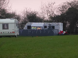
Street. It is a fairly narrow stony track lined with hedgerows. Near to High Cross there is a camping site on
the left which seemed to be fairly busy and one of the Leicestershire Beacons
stood in the field of the campsite.
 |
| Caravan decorated with Christmas Lights. |
High Cross is close to the boundary of
Leicestershire and Warwickshire, with Warwickshire just across the A5. It is 443 feet above sea level, which makes it
a natural vantage point which dominates the surrounding countryside in all
directions. At about the same time as The Fosse Way was constructed, the Roman
garrison built the township of Veronis at High Cross. Archaeological
evidence suggests that there was also an Iron Age settlement on this same
site. The stone-built pillar which now stands at High Cross is all that
remains of a monument erected by The Earl of Denbigh and others in 1712 to mark
the centre of Roman England and occupies the site of a wooden cross which had
stood for several centuries previously. Originally a much larger and ornate
structure was sited in the centre of Watling Street (now the A5), adjacent to
the junction of the Southern Fosse Way. In 1791 it was wrecked by lightning and
the remnants re-erected in its present position.
 |
| High Cross Monument The centre of Roman England |
Distance
We walked a
total of 4.3 miles
Next
Walk
The next and
final walk will be from High Cross back to where we started at Dunton Bassett,
planned for New Years Eve, 31st December 2016.
No comments:
Post a Comment