Saturday 31 December 2016

Walk 13 – Claybrooke Magna to Dunton Bassett


We did this final section of the walk on Saturday 31st December 2016 – New Years Eve.  Just a few days before we did not think we were going to meet our target of finishing before the end of the year but now it was reality.  The weather was mild and dry but very misty when we started.  Towards the end the sun came out and it turned into a bright afternoon.

 
Claybrooke Magna to Frolesworth

Bell Lane, Claybrooke Magna

The route took us straight out of Bell Lane, Claybrooke Magna near to where we had entered it, so no chance to see any of the village without a detour. 
  

Claybrooke Mill Stream away from
the Mill


We walked through a grassy field and then over crop fields to Claybrooke Mill.  We didn’t see the actual mill but crossed a bridge over the mill stream and got a glimpse of the secluded mill house together with a family of ducks on the water. 


Claybrooke Mill Stream looking
 towards the Mill
 
There was a short walk from the mill up to cross the road between Frolesworth and Claybrooke Magna.  We had a good view across to Claybrooke Magna as the mist started to lift.

View to Claybrooke Magna, where we started today
Fishing Lake at Manor Farm, Frolesworth
 
The onward path took us around stables and up to a farm track from where we had good views over a fishing lake at Manor Farm.                               
 
We arrived in the village of Frolesworth and looked back to get good views of the surrounding countryside over which we had just walked. 

View from Frolesworth over surrounding countryside
 
Frolesworth is a very small village with about 80 properties.  It has a single road and most of the houses are either on this road or slightly set back from it.  At the centre of the village is St Nicholas Church which dates back to the 13th century. The church commands the highest ground in the village.
Oak Tree planted in 2012 to commemorate
The Queens Diamond Jubilee

St Nicholas's Church, Frolesworth


Frolesworth to Leire

We walked along the road through Frolesworth passing the church on our right and a tree planted to commemorate the Queens Diamond Jubilee in 2012.  After leaving the village we were soon back across fields making towards the village of Leire.   We gradually moved away from the road and up over a hill from where we could see the spire of Leire church.  We crossed a few more muddy fields and arrived in the village having crossed a strip of land where the former Midland Counties Railway used to run. 
The Midland Counties Railway used
to run along this strip of land

Leire is a small village with a population of about 500 according to the 2011 census.  The name is thought to originate from the pre-English name for the nearby River Soar – The Legra, a tributary which has its source to the south of the village..    The village church of St. Peters dates back to the 14th century.  There are 2 pubs, the Queens Head and the Crab and Cow, formally the White Horse.
Attractive front garden in the vilage


The village used to have its own railway station – Leire Halt – on the former Midland Counties Railway running from Leicester to Rugby.  It was opened in 1925 and closed, along with the whole line in 1962.  Part of it has been turned into the Jubilee Nature Walk running south towards Ullesthorpe.
 

Leire to Dunton Bassett


The Crab and Cow pub in Leire, formally the White Horse


We stopped at a seat in Leire and had a drink and snack before continuing past the Crab and Cow and then down Stemborough Lane towards Stemborough Mill.  There were now a lot more breaks in the cloud and the sun started to shine.


Stemborough Mill House is a grade II listed building and sits alongside a trout farm.  We crossed the stream which runs from the Trout Lakes to Broughton Astley via our garden.  Trout do escape from the farm occasionally and we have seen them in the part of the stream that runs through our property.

Stemborough Mill House

Stemborough Mill Trout Farm Lakes


The final leg of our walk took us past the trout lakes and alongside farmland, where there were grassy areas to walk on and up a grass field into Dunton Bassett, back where we had started our Leicestershire Round walk over 9 months earlier on 27th March 2016.


Nearly there - Dunton Basset Church comes into view

Dunton Bassett is a small village lying close to the M1 motorway.  It has one pub - The Dunton Bassett Arms or DBA and the village church is All Saints.  The Great Central Railway, the last main line to be built from the North to London in 1899 ran just to the east of Dunton Bassett.  There was a station but its name was given to nearby Ashby Magna. A short tunnel to the south was named the Dunton Bassett Tunnel. In later years the M1 was built to run parallel to the railway which closed on 5 May 1969.


The End - Back at the Dunton Bassett Arms

Distance

We walked a total of 5.65 miles and did about 14,000 steps.

We have now completed the Leicestershire Round as we intended, within the year 2016.


Friday 30 December 2016

Walk 12 – High Cross to Claybrooke Magna


We did this very short section of the walk on Friday 30th December 2016.  Now that the remaining sections of the Leicestershire Round are very close to home it is much easier to do shorter walks as it is just a short drive to both start and end points.  Paul had suffered some leg pain on the previous 2 walks and wanted to do a shorter one today to see if bandaging the affected area would help.  Fortunately it did and he was perfectly ok.  This walk was planned to be about 3.5 miles as the official guide book said that the distance from High Cross to Claybrook Parva was 3 miles but it turned out to be only 1.5 miles and then the further half mile to Claybrooke Magna made it just over 2 miles.  The weather was much warmer than the previous day and despite it being sunny for most of the morning and early afternoon, the fog was now starting to form so we could not see the nice views that are normally possible from this high area.


High Cross to Claybrooke Parva
After leaving the first car at the end point, we parked the car in the small car park and had a good look at the High Cross monument before starting off. 


There is an inscription on it in Latin.  I found the translation on the internet as follows:

'If Traveller, you seek for the footsteps of the ancient Romans, here you may behold them, for here their most celebrated ways, crossing each other, extend to the utmost bourne'


The High Cross Monument


The monument was created in 1712 but damaged by lightening in 1719.  This is all that remains of a once much grander construction.


We then left High Cross and walked a short distance to the end of Bumblebee Lane and then into High Cross Road.  The Victoria Farm caravan and camping site that we saw on the previous days walk (a certified Caravan Club site) was on our left now and we walked close to the beacon in the field. 

One of the Leicestershire Beacons
situated in a camping site field at High Cross

We left the road and started out across some crop fields which were extremely muddy and soon our boots were feeling very heavy with the extra weight of the mud.  Not only was it very misty and dull but we had the noise of the traffic on the nearby A5 together with a couple of barking dogs at a nearby farm or property.  This went on until we had almost reached Claybrooke Parva.

We entered Claybrooke Parva alongside the village primary school.  Opposite there is Sykes Spinney, a small coppice owned by the school where hopefully the children learn about nature.
Sykes Spinney, Claybrooke Parva

The Claybrookes consist of the 2 small villages of Claybrooke Parva and Claybrooke Magna.

Claybrooke Parva, although the smaller of the two villages, is the site of both the church and the village school.  The parish church of St. Peter is thought originally to be part Anglo-Saxon with later additions in Norman and Medieval times.  It has a square tower with a working clock, the tower houses a peel of 8 bells which regularly ring out over the countryside.  The roof beams are fine examples of medieval craftsmanship, but unfortunately have been damaged by death watch beetles.

 
The main street through Claybrooke Parva


Claybrooke Parva to Claybrooke Magna

We walked a short distance along the main street and then turned off across more fields towards Claybrooke Magna.  We passed Claybrooke Hall and grounds to our right but it was too misty to see much of it.  This part of the walk was mainly across grass and was much easier. We entered the village very close to where we had left the car. 
 
The mist forming over fields between
Claybrooke Parva and Claybrooke Magna
 
Claybrooke Magna is the larger of the two villages with a population of around 400 people.  A few of the houses were built in the 1990’s, but others are much older with buildings dating to Victorian and Georgian times, with some half-timbered Tudor houses by the Vineyard.  A little way out of the village is an old water-mill, still in working order, which is driven by the small stream which winds its way through the area. Claybrooke Magna has seven grade II listed buildings.  The village pub is called “The Pig in Muck” and is very popular.

An older photo of "The Pig in Muck" pub. 

Distance

We walked a total of 2.27 miles in less than 1 hour and did about 6000 steps

Next Walk
The next and final walk will be from Claybrooke Magna to Dunton Bassett, planned for New Years Eve - 31st December 2016.


Thursday 29 December 2016

Walk 11 – Aston Flamville to High Cross


We did this section of the walk on Thursday 29th December.  We only had a couple of hours in the late afternoon so had to make it a short one.  It was a cold and frosty day where the temperature didn’t go above 3 degrees centigrade but the sun was shining and as we were now on a south eastward path, was not in our eyes.

 
Aston Flamville to Sharnford
We started mid afternoon and made our way back onto the footpath, down a farm track and across fields to Sharnford.  Surface water around the stiles and on the farm tracks was frozen, as was the mud in the fields so made it a much easier walk than the previous one.  The parts of the fields that had not seen the sun remained white, looking as if it had snowed.  We crossed the River Soar, which runs through Sharnford and entered the village very near to the one way triangle. 
 
Field with frost in areas of shade


Ice covered brook

 
Sharnford had about 1,000 residents at the 2011 census.  The hamlet of ‘Scerneford’ belonged to Wulfric Spot, Earl of Mercia during the Danelaw in the 10th century and was probably named after a "scearn" or muddy ford over the River. The village is likely to have been occupied by the Danish from the 9th century.


Main Road in Sharnford
The Church of St. Helens originates from 1180 although much of the building today dates from the 15th century.  It was badly damaged by a fire in 1984 resulting in extensive repairs.

During the English Civil War soldiers from the local garrisons visited Sharnford in search of fresh horses and "provinder" (horse fodder).


Sharnford to High Cross

We walked through the village, past the Countryman pub and turned off to follow the River Soar into Fosse Meadows. 
The River Soar in Sharnford Village Cenre


Sun just below the tree line at Fosse Meadows
 
The sun was now mainly lower than the woodland in the country park so not as bright as earlier in the walk.
  
Fosse Meadows is a large nature area with grass fields, a lake, an arboretum and an extensive network of paths crossing through it. 


We followed the route through Fosse Meadows and stopped for a short rest and drink at one of the bird hides overlooking the lake. 
The lake at Fosse Meadows from the bird hide
 
The route then took us out of the country park and over a few more fields until we reached the Fosseway.  At this point we had the best sunset view over the meadows.
Sun setting over Fosse Meadows
 
Fosseway The section of the Fosseway which is on the Leicestershire Round is one of the few to have survived in anything like its original form.
Fosseway
 
The Fosse Way rises gently to High Cross on Watling Street.  It is a fairly narrow stony track lined with hedgerows.  Near to High Cross there is a camping site on the left which seemed to be fairly busy and one of the Leicestershire Beacons stood in the field of the campsite. 
 
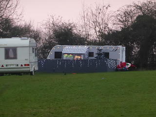
Caravan decorated with Christmas Lights.
 

High Cross is close to the boundary of Leicestershire and Warwickshire, with Warwickshire just across the A5.  It is 443 feet above sea level, which makes it a natural vantage point which dominates the surrounding countryside in all directions. At about the same time as The Fosse Way was constructed, the Roman garrison built the township of Veronis at High Cross. Archaeological evidence suggests that there was also an Iron Age settlement on this same site. The stone-built pillar which now stands at High Cross is all that remains of a monument erected by The Earl of Denbigh and others in 1712 to mark the centre of Roman England and occupies the site of a wooden cross which had stood for several centuries previously. Originally a much larger and ornate structure was sited in the centre of Watling Street (now the A5), adjacent to the junction of the Southern Fosse Way. In 1791 it was wrecked by lightning and the remnants re-erected in its present position.

High Cross Monument 
The centre of Roman England
The light was fading fast by the time we finished the walk and arrived back to our car, parked near to the High Cross monument.
 

Distance
We walked a total of 4.3 miles

Next Walk

The next and final walk will be from High Cross back to where we started at Dunton Bassett, planned for New Years Eve, 31st December 2016.


Monday 26 December 2016

Walk 10 - Sutton Wharf to Aston Flamville


We did this section of the walk on Boxing Day, Monday 26th December 2016.  As there are no pubs or cafes on todays route, we took mince pies and a flask of hot mulled wine for our lunch stop.  It was a glorious day with bright sunshine throughout but as we were walking south, and the sun is very low in the sky at this time of year, it was constantly in our eyes.


Sutton Wharf to Barwell

We left Sutton Wharf at 9.30 am and the first part of the walk was along the Ashby Canal Tow Path which was quite muddy in places.  There were a lot of narrow boats moored near to the Wharf and some others making their way through but soon the canal was completely still with only ducks and moorhens disturbing the still water.


Ashby Canal from bridge where we left
to follow route to Barwell
 
We then left the canal and walked through fields of winter root vegetables, including parsnips and swedes and other newly ploughed fields which were extremely muddy and made it a bit slow going.  There were a couple of grassy fields before reaching Barwell so we were able to clean our boots a bit before walking on the village pavements.
 
Field of root vegetables, possibly parsnips

We only passed through a small corner of Barwell so didn’t see much of it.  It is a large village and suburb of Hinckley having a population of around 9,000 at the 2011 census.  The name translates as "Stream of the Boar" and is said to originate from a boar that used to drink from the well near a brook in the village.  Its originally name was Borewell and the brook is now called the River Tweed, a tributary of the River Trent.

Barwell and neighbouring Earl Shilton were the site of a meteor event when, on Christmas Eve 1965, the villages were showered with fragments from an object about the size of a Christmas turkey. No one was hurt, although some minor damage to buildings and property occurred.  One meteorite went through the front of a car, destroying the engine. The insurance refused to pay out as it was an "Act of God" so the owner went to the priest of the local church and asked for the repair money, saying "If it was an Act of God, the Church should pay for his car." but this claim was not successful either.  The fragments were confirmed to be from a chondrite, a stony, non metallic meteorite. Locals were asked to hand in any further specimens to the local police station.  A piece of the meteorite is on display at the Herbert Museum in Coventry.
 

Barwell to Burbage

We left Barwell going straight into a grass field with quite a few white shire horses and foals.  They were standing so still they looked like statues from a distance. 
White shire horses in Barwell
Friendly horse near Barwell
 
We then crossed the busy A47, Leicester to Hinckley road and made out way to Burbage Common and the Hinckley Golf Club grounds.  There were a large number of families and dogwalkers around the common and quite a few enjoying a game of golf.  We had a pleasant walk through Sheepy Wood, where we had some respite from the sun before crossing under the Leicester to Hinckley railway line. 
 
Sheepy Wood
 
Shortly after crossing the railway we saw a sign to a farmhouse who were advertising “light refreshments”.  This was Mays Café at Woodhouse Farm, Burbage Common.  We could see some picnic tables in front of the café so made our way over to have our lunch.  The café was closed so we sat down and poured our mulled wine and opened the bag of mince pies.  Other walkers saw us and must have thought that the café was open so made the short detour only to be disappointed to find it closed.

Robin who probably cleared up the crumbs
from the mince pies
 
Mulled Wine and Mince Pie lunch

The walk took us along the side of Burbage Wood and on into the outskirts of the village of Burbage.

Burbage Common and Wood is a country park run by the borough council. Its history as a grazing area dates back to at least the Domesday Book of 1086 and is now a 200-acre (0.81 km2) park popular with birdwatchers, walkers and horse riders. It is free to enter and is open from dawn to dusk every day.

One of the many entrances to Burbage Common and Woods 

View of part of Burbage Common


The village of Burbage, another suburb of Hinckley and somewhat smaller than Barwell, was given to Coventry Abbey in 1043 when it was valued at two shillings. At the time of the Domesday Book in 1086, its value had risen to £4. At that time 20 villagers held two smallholdings, with two slaves and eight ploughs.

 
Burbage to Aston Flamville

The final leg of todays walk took us through a small residential part of Burbage and into fields of cattle towards the noisy M69 motorway and on to Aston Flamville. On either side of the M69 we saw a few Alpacas enjoying the sunshine. 

Alpaca farm near the M69 motorway

We crossed the M69 and walked into the village of Aston Flamville passing some lovely houses to our left and an 18th century dovecote to our right, near the church.  We found our car which we had parked outside St. Peters Church. 

St Peters Church, Aston Flamville


18th century dovecote next to church
Aston Flamville is a small picturesque village with a population of 311 at the 2011 census.  It is situated on the eastern side of the M69 motorway and unfortunately the traffic noise can be heard throughout the village.  The name comes from 2 words, Aston – meaning Eastern Farmstead or settlement and Flamville – the family name of a Norman nobleman (of William the Conquerer) called Robert de Flamville who owned the Manor House of Aston, built in the 1500’s.


Distance

We walked a total of 8.64 miles and my new Sports Activity watch, that was a Christmas present from Paul, showed a total of 22,000 steps.

Next Walk

The next planned walk will be from Aston Flamville to Claybrook Parva, planned for New Years Eve 2016.